| The Last Stand Bea often reminds me how fortunate we are that we can live a life like we do. And look how right she is. We do not need to sit out a nasty winter up north, we travel in comfort and every day we can buy our food without fear for the next day. We are relatively healthy, we have lots of dear friends all over the world, but yet we catch ourselves time after time complaining about high gas prices, the pot holes in the road or a closed bridge. :-)) Just to mention a few examples. And yesterday was a day when I really felt like thanksgiving. Whether we call it the Last Stand or the Last Supper, it was a nice gathering with our “family of friends” in the warm afternoon sun. Almost all the meatballs were eaten and yes, there was a rich dessert for Peter and his friends.  After supper we lit the fire and were sitting and chatting around until a cool breeze sprang up and made us look for a warmer place.  Pulling up Stakes Today the last day at the Hot Springs, we have to pull up stakes, and start stowing everything away. It won’t be a long drive – just 40 miles to Yuma, but yet it is the final Good Bye to the Holtville Hot Springs. Maybe I take a last soak in the hot water. |

Showing posts with label California. Show all posts
Showing posts with label California. Show all posts
Sunday, March 4, 2012
Thursday, March 1, 2012
| Mountains, Snow, but very little Flowers This was a trip we have been looking forward to. At 8am 2 vehicles and three couples were ready to go west. Destination: Julian and Santa Ysabel. Julian the capital of apple pies and Santa Ysabel where Dudleys Bakery was our goal. The coastal mountain range with snow capped peaks along Hwy 78 were gleaming against a blue western sky. The road climbed higher and higher until we reached Julian at over 4000ft. Long before we got to town snow was piled up along the road. So, of course, we didn’t work up a sweat when we were walking along pretty Main Street. A store owner, standing in her door told us that the snow had come on Tuesday and created a bit of havoc in town. But it was pretty too and the many cars parked in town told us that the tourists didn’t really mind to climb over piles of snow when the wanted to cross the street. |


| We got home just before 5.30pm and I must admit: I am played out. Thanks for stopping by! |
Wednesday, February 22, 2012
What's up?
Today there is nothing much to report.
We are enjoying a lot of very nice weather out here, and tomorrow it's gonna be even warmer (84F). But do we complain about hot weather? Noooo we don't.
But the bugs are coming, you say?
Yeah, there are a few, but so far it hasn't been too bad. Lizards are around as well, but what about snakes? Aren't snakes working under the same conditions as lizards? I think they do. So be aware of snakes when venturing out in the hot desert sun.

We are planning a trip out into the Borrego area again. Spring flowers are always a wonderful sight and worth the drive, and Borrego is a world reknown area for the early spring blooms. Of course, when doing the drive west we are also bound to end up in Julian.
Julian has a famous bakery and I can kinda smell the apple pies all the way over here. And you know what that does to me, right?

And I guess that's it from here for today.
And if you feel it's getting too hot, stay in the shade!
Thanks for visiting.
Today there is nothing much to report.
We are enjoying a lot of very nice weather out here, and tomorrow it's gonna be even warmer (84F). But do we complain about hot weather? Noooo we don't.
But the bugs are coming, you say?
Yeah, there are a few, but so far it hasn't been too bad. Lizards are around as well, but what about snakes? Aren't snakes working under the same conditions as lizards? I think they do. So be aware of snakes when venturing out in the hot desert sun.
We are planning a trip out into the Borrego area again. Spring flowers are always a wonderful sight and worth the drive, and Borrego is a world reknown area for the early spring blooms. Of course, when doing the drive west we are also bound to end up in Julian.
Julian has a famous bakery and I can kinda smell the apple pies all the way over here. And you know what that does to me, right?
And I guess that's it from here for today.
And if you feel it's getting too hot, stay in the shade!
Thanks for visiting.
Monday, November 28, 2011
"Slab City"
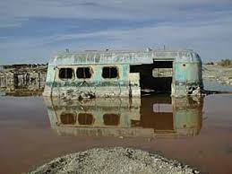 It takes its name from the concrete slabs and pylons that remain from the abandoned World War II Marine barracks Camp Dunlap there. A group of servicemen remained after the base closed, and the place has been inhabited ever since, although the number of residents has declined since the mid 1980s.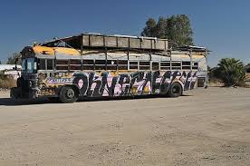
Several thousand campers, many of them retired, use the site during the winter months. These snowbirds stay only for the winter, before migrating north in the spring to cooler climates. The temperatures during the summer are unforgiving; nonetheless, there is a group of around 150 permanent residents who live in the Slabs all year round. Most of these "Slabbers" derive their living by way of government checks (SSI and Social Security) and have been driven to the Slabs through poverty.
The site is both decommissioned and uncontrolled, and there is no charge for parking. The camp has no electricity, no running water or other services. Many campers use generators or solar panels to generate electricity. Supplies can be purchased in nearby Niland, California, located about three miles (5 km) to the southwest of Slab City.
Located just east of State Route 111, the entrance to Slab City is easily recognized by the colorful Salvation Mountain, a small hill approximately three stories high which is entirely covered in acrylic paint, concrete and adobe and festooned with Bible verses. It is an ongoing project of over two decades by permanent resident Leonard Knight. I have been blogging about it before and you can access the posting here.


It is certainly not for everybody and we have never stayed there, just visiting the place a few times, but SLAB CITY as it is called, is still populated by Snowbirds and year-round squatters from across North America.
Several thousand campers, many of them retired, use the site during the winter months. These snowbirds stay only for the winter, before migrating north in the spring to cooler climates. The temperatures during the summer are unforgiving; nonetheless, there is a group of around 150 permanent residents who live in the Slabs all year round. Most of these "Slabbers" derive their living by way of government checks (SSI and Social Security) and have been driven to the Slabs through poverty.
The site is both decommissioned and uncontrolled, and there is no charge for parking. The camp has no electricity, no running water or other services. Many campers use generators or solar panels to generate electricity. Supplies can be purchased in nearby Niland, California, located about three miles (5 km) to the southwest of Slab City.
Located just east of State Route 111, the entrance to Slab City is easily recognized by the colorful Salvation Mountain, a small hill approximately three stories high which is entirely covered in acrylic paint, concrete and adobe and festooned with Bible verses. It is an ongoing project of over two decades by permanent resident Leonard Knight. I have been blogging about it before and you can access the posting here.

Today was a hot day with temps around the 80F. Nevertheless I went ahead and made a cheese cake. It was a first for me, and since we haven't had a bite of it (the thing must cool down first) we don't know whether it's edible. But I am hopeful. Our friend and neighbour Earl has his birthday today and he should be celebrating today, but the day was marred for him as the fridge in his Motor Home won't work. He replaced two electronic boards, but nothing helped. So part of their stuff is now in our fridge.

So long, friends, stay cool in the heat and warm if you are still up north.
Sunday, November 27, 2011

For us snowbirds and boondockers it is important to be not too far removed from common town facilities, such as fresh water and propane supply. Also shopping for groceries should not necessitate a 100mile-drive.
Thus the small town of Holtville, being 8 miles away is just what we need to have nearby. Holtville has a privately run dump station two grocery stores and a couple of gas stations. Of course we also receive our mail there and there is a local bank in town. That, pretty much covers the basics. For other things we make the drive to El Centro or sometimes even to Yuma, AZ.
The city of Holtville was founded by Swiss-German settlers in the 1880s often coming in through the U.S.-Mexican border from Mexico. The construction of railroads in the 1890s, the All-American Canal in the late 1940s, and U.S. Route 80 in the 1920s which later was converted to Interstate 8 in the 1970s, and the North American Free Trade Agreement (NAFTA) led to an economic boom in the 1990s and brought more people to Holtville and the Imperial Valley.
The city of Holtville, which was originally called Holton, was founded in 1903 by W.F. Holt, and incorporated on June 20, 1908. The name was changed to Holtville due to a request by the Postal Service because the name Holton sounded too much like Colton, (in San Bernardino County), the regional headquarters of the Southern Pacific Railroad at the time.
The city lies on the northeast bank of the Alamo River formed by the floods of 1905-07 when the Colorado River break made the river's course turn west and filled the low-lying depression of water now the Salton Sea.
The old U.S. Route 80 once ran along Fifth Street through the center of town. A small obelisk in Holt Park, just north of Fifth Street, gives the distances to various points to the north, east and west. U.S. Route 80 has been decommissioned and made a County Route S80 in California.
Much of the east-west automobile traffic has been diverted to Interstate 8, about 2.5 miles to the south. Holtville is easily accessible through the Orchard Road interchange. The newly constructed State Route 7 connects Holtville with the factories and industrial areas of Mexicali, Baja California, Mexico.
The city was once joined by railroad to El Centro, but this line (nicknamed the "Holton Interurban"), and another railroad line going to the north, have been abandoned. The closure of the railroad station brought on economic decline to the town in the late 20th century.

 The city's major civic event is the annual Carrot Festival, held in late January or early February. It usually features a parade, a carnival and other activities over a 10-day period.
=======================================================================================The city of Holtville was founded by Swiss-German settlers in the 1880s often coming in through the U.S.-Mexican border from Mexico. The construction of railroads in the 1890s, the All-American Canal in the late 1940s, and U.S. Route 80 in the 1920s which later was converted to Interstate 8 in the 1970s, and the North American Free Trade Agreement (NAFTA) led to an economic boom in the 1990s and brought more people to Holtville and the Imperial Valley.
The city of Holtville, which was originally called Holton, was founded in 1903 by W.F. Holt, and incorporated on June 20, 1908. The name was changed to Holtville due to a request by the Postal Service because the name Holton sounded too much like Colton, (in San Bernardino County), the regional headquarters of the Southern Pacific Railroad at the time.
The city lies on the northeast bank of the Alamo River formed by the floods of 1905-07 when the Colorado River break made the river's course turn west and filled the low-lying depression of water now the Salton Sea.
The old U.S. Route 80 once ran along Fifth Street through the center of town. A small obelisk in Holt Park, just north of Fifth Street, gives the distances to various points to the north, east and west. U.S. Route 80 has been decommissioned and made a County Route S80 in California.
Much of the east-west automobile traffic has been diverted to Interstate 8, about 2.5 miles to the south. Holtville is easily accessible through the Orchard Road interchange. The newly constructed State Route 7 connects Holtville with the factories and industrial areas of Mexicali, Baja California, Mexico.
The city was once joined by railroad to El Centro, but this line (nicknamed the "Holton Interurban"), and another railroad line going to the north, have been abandoned. The closure of the railroad station brought on economic decline to the town in the late 20th century.


Yet another follower has jumped aboard, and I dare say it's someone
I know very well. Wilfried is a fellow I went to school with back in the sixties in Germany. Willkommen an Bord Wilfried! I know Wilfried would prefere everything I scribble in German, but that's too much of a work load.
Thanks for looking in here.


The Imperial Valley
The first time we came into the Imperial Vally we were mighty astonished to find such a vast agricultural area being so close to a dry desert landscape. The valley is located in southeastern Southern California, centered around the city of El Centro. Locally, the terms "Imperial Valley" and "Imperial County" are used synonymously. The Valley is bordered between the Colorado River to the east and, in part, the Salton Sea to the west. Farther west lies the San Diego and Imperial County border.
The reason for the far-stretched agricultural landscape is the All-American Canal which conveys the rich water supply, from the Colorado River into the Imperial Valley.
 |
| Neatly prepared agricultural fields |
 |
| Irrigation Pipes along the Highway |
It is the Imperial Valley's only water source, and replaced the Alamo Canal, which was located mostly in Mexico. The Imperial Dam, about 30 miles (48 km) northeast of Yuma, Arizona on the Colorado River, diverts water into the All-American Canal, which runs to just west of Calexico, California before its last branch heads mostly north into the Imperial Valley. Six smaller canals branching off the All American Canal move water into the Imperial Valley. These canal systems irrigates up to 630,000 acres (250,000 ha) of good crop land and has made possible a greatly increased crop yield in this originally semi-desert area. It is the largest irrigation canal in the world, carrying a maximum of 26,155 cubic feet per second (740.6 m3/s)
 |
| The All-American Canal as it runs by the Hot Springs LTVA |
The Imperial Valley is rich in natural beauty, local history, and culture. The unique culture of the area blends the two different countries of the United States with Mexico, due to its regional history and geographic location along the international border. This creates a small town atmosphere, and an economy based on agriculture, and a strong work ethic for the people of the valley. From early in January through the winter holiday season, the Imperial Valley hosts many festivals and activities that keep things moving. From the North to the South. Imperial Valley offers visitors and residents a taste of many cultures such as those from Mexico with all its sights, sounds and tastes waiting to be savored.
El Centro is the promising new major commercial and industrial center of Southern California for the imperial valley, being the center of shipping exports as well as being home to retail, transportation, wholesale, and agricultural industries. There are also two international border crossings nearby for commercial and noncommercial vehicles. The city's population was 37,835 at the 2000 census. The 2006 population is 40,563. The city is 50 feet (20 m) below sea level and the largest city in the United States below sea level. Fifty percent of the jobs in El Centro come from the service and retail sector. However, the economic recession hit El Centro and surroundings hard, and the city has a current unemployment rate of more than 25%.
 |
| Strong hispanic traditions in the Imperial Valley |
 |
| Anza Borrego in Spring - blooming Desert |
Two new followers have joined the American-Traveler. Be welcome, Sue and Doug from Big Dawg and Freeway an Ruth from Five-Just Rolling Down the Road
Thanks again for stopping by.
Thursday, November 24, 2011
A cool Thanksgiving Day
The early morning showed a thin band of dark clouds above the eastern horizon, and only an hour later these clouds had spread almost over the entire sky, only way out, toward the west, was still a blue sky. This weather lasted the whole day and turned this day into a rather cool Thanksgiving event. But anyway, we had our Turkey Thanksgiving supper within our fellowship of friends at the Host Station. And it was good sitting together and having a chit-chat about this and that.
Earl and Carol came finally down by car from Saskatchewan yesterday but couldn't get their motor home out of the storage as the starting battery was flat. So they slept in the Motor home inside the storage and today we drove to El Centro, where Walmart was the only store being open, and purchased a new battery. After it was mounted. the coach sprang to life and all there is left to do now, is getting all the stuff they brought stowed into closets and cupboards.
More and more RV-owners leave their rigs in the south, in order to save on fuel costs. However, it is a real calculation how much one can save, as going by car would require overnight stays in a motel and eating in restaurants, plus the fee for the storage.
Now the last part of our west coast drive in 2005:
The early morning showed a thin band of dark clouds above the eastern horizon, and only an hour later these clouds had spread almost over the entire sky, only way out, toward the west, was still a blue sky. This weather lasted the whole day and turned this day into a rather cool Thanksgiving event. But anyway, we had our Turkey Thanksgiving supper within our fellowship of friends at the Host Station. And it was good sitting together and having a chit-chat about this and that.
Earl and Carol came finally down by car from Saskatchewan yesterday but couldn't get their motor home out of the storage as the starting battery was flat. So they slept in the Motor home inside the storage and today we drove to El Centro, where Walmart was the only store being open, and purchased a new battery. After it was mounted. the coach sprang to life and all there is left to do now, is getting all the stuff they brought stowed into closets and cupboards.
More and more RV-owners leave their rigs in the south, in order to save on fuel costs. However, it is a real calculation how much one can save, as going by car would require overnight stays in a motel and eating in restaurants, plus the fee for the storage.
Now the last part of our west coast drive in 2005:
| November 04 We say farewell to Refugio State Beach and its wonderful campground and head farther south towards Los Angeles. Highway 101 follows the beaches for miles until we have to take off towards San Bernadino. The freeways around L.A are 4 to 5 lanes in every direction and lots of big trucks are coming up from behind all the time. Finally after several hours on L.A. Highways we reach Victorville at Interstate 15. We have ordered a solar panel here which we plan to install while being on a campground. Victorville, a town in the desert is all spread out and the traffic here is terrible. Our campground, the KOA lies directly besides the Interstate and accordingly the noise is deafening. Definitely not a place to spend your vacations on. However we have desert temperatures and during the day it gets up to 30 C. November 05 The morning starts out busy as we have to get downtown to purchase some groceries and accessories for mounting the solar panels. The shopping takes more than a couple of hours, because we can't find a food mart. First after lunch I can start on my work with the solar panels. Unfortunately some parts are missing and I have to improvise to get it all done. Now I need another day to finish up the installation. November 06 Another day working at Victorville. While I am buzzing about Bea washes the outside of our rig. November 07 Aah, what a relief to leave this noisy place behind. |
 | Interstate Traffic | |
 | ||
 | In the desert | |
 | ||
| We travel through the High Desert landscape. Lots of Yuccas on both sides of the Highway 247 as it leads through Yucca Valley. As Highway 247 climbs down and enters Riverside County we cross a huge area filled up with wind mills. | |
 |  |
| Bell Mountain at Hwy 247 | |
 | |
 Windpark at Palm Springs Windpark at Palm Springs | |
leave at Coachello. Highway 86 gets us farther south and for the first time we see Palm Tree Nurseries along the road. Our destination for the day is Mecca Beach at the Salton Sea. From the village of Mecca Highway 111 runs on the east side while Highway 86 runs south on the west side of the lake. Mecca Beach lies on the east side and is just one of 5 local campgrounds belonging to the California State Recreation Area. The first campground we see is the local Headquarters. A very friendly lady Ranger offers us a job as camp hosts for as long as the season goes. We receive an application but decide to look around before we accept her offer. After settling in for the night at the headquarters campground we drive down Hwy 111 until we reach the little village of Niland. Of the 5 State Recreational Campgrounds only Mecca Beach and the Headquarters can be recommended for a longer stay. These sites are very well maintained and offer a few hook-ups , a day-use area and shaded tables. They are spacious enough to accommodate big rigs too. Headquarters campground has a very nice little marina and a service building surrounded by beautiful palm trees. The Salton Sea is only 100 years old as it was created when the Colorado River went on a rampage in 1905. having created a dam of sediments against the California Gulf the mighty river found an outlet to the north, filling a low basin between two mountain ranges. It created the Salton Sea. However the basin is so low that there was no further outlet for the water. When reaching the height of the sediment barrier towards the Gulf the Colorado again found back into its previous bed and washed out into the Gulf again leaving the Salton Sea to its own. Evaporation was leading to an increase of salinity and while no water outlet was possible an increasing amount of salt remained in the lake. The water is of a reddish color and does not appear to attract many visitors these days, and that should not surprise as the lake is heavily polluted, and produces a profound ugly smell. | ||
Subscribe to:
Posts (Atom)